

PHILADELPHIA, Pennsylvania (GBT) – An 18th century map depicting the area of West Hempfield Township, Lancaster County, formerly known as Hempfield Manor, shows the original boundary lines of the land that John Hougendobler purchased from John Penn the Elder and John Penn the Younger in December of 1789. The Penns were cousins of each other and grandsons of William Penn, the founder of Pennsylvania. The map is currently archived in the Cadwalader Collection of the Historical Society of Pennsylvania.
Although the Hempfield Manor map is undated, it was filed alongside a similar map of Conestoga Manor that was dated September, 1789. Both maps were examined and drafted by direction of Anthony Butler, Esq., and copied by the noted cartographer Charles de Krafft. While the map of Conestoga Manor was backed with linen, the map of Hempfield Manor was in an unrestored and fragile condition.
The map shows a 244 acre plot of land bordered by the Susquehanna River on the west, from roughly the Point Rock Tunnel at the south to present-day Klinesville Road and Cardinal Drive at the north, and extending east to around the area of present-day Klinesville. The area encompasses much of the land known today as Chickie's Rock County Park.
Historically, the bank of the Susquehanna River once followed what is now the Northwest Lancaster County River Trail, which was formerly the Columbia Branch of the Pennsylvania Railroad. The path of the river's bank has since been altered, first by the construction of a new railway over part of the river, and then by terrain-altering floods in 1936. Present day satellite images of the area now show reforested land between the Northwest Lancaster County River Trail and the bank of the Susquehanna River that did not exist at the time of the original purchase. See MichaelFroio.com and Susqnha.org for more information about this history.
"Seeing this map really took my breath away," said family historian Tim G., "If I had known it was going to be this cool, I would have brought my good camera. I managed to capture a few good shots with my cell phone and made a composite of the best of them. It's not bad actually, but my other camera would have been better."
Although the cell phone composite pictures turned out pretty good, the full original map will not be published for general viewing on GenealogyByTim.com any time soon.
Tim explained, "At the Historical Society of Pennsylvania, they let you take pictures of things, but you can not use a flash, and they make you place a card nearby that says 'Usage Rights Not Granted' and some other legal stuff. They want you to negotiate with them for the rights to republish. That's fair. Maybe one day, when I'm a rich and famous genealogist, I'll obtain the republication rights. Until then, I guess it'll be my little secret."
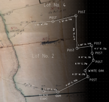
The map aligned almost perfectly with CAD image that Tim created from the description of the land in the original deed. "I've been experimenting with different mapping software for Linux. TractPlotter.com is a very cool free resource that will give a quick outline of the tract, based on the calls in the deed. From there, I was able to create a more detailed image using LibreCad. As cool as these software programs are, they're limited because they can't place the tract on an actual map. QGIS might have that capability, with the Azimuth and Distance plugin installed. I'll be experimenting with that next."
The map was discovered as part of a research project that Tim has undertaken to gain admission into Pennsylvania Ancestors Lineage Society, a division of the Genealogical Society of Pennsylvania. Some generational links are currently known only to be provable by land records. Documenting the provenance of the land in question increases the evidentiary value of the deeds across generations. ⬮
Comments